Archaeological
Research Conducted in
in the
A Report of Investigations Carried Out
under a Program of Research Entitled “Defining the Paleolithic Presence on the
Tibetan Plateau” Supported by the American Council on Learned Societies
& the Henry Luce Foundation

Mark S. Aldenderfer
John W. Olsen
Department of Anthropology
The
&
P. Jeffrey Brantingham
Department of Anthropology
18 February 2008
Archaeological research conducted in
Introduction
Research during the 2007
season focused on the following research goals: 1) conducting reconnaissance
level survey in three areas of the Sutlej (Langchen Khebab; 象泉河) river drainage in

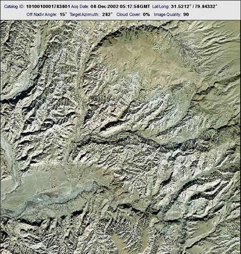
Figure 1.
The larger research goals of
this project are to examine questions regarding the initial peopling of the
Tibetan Plateau and to determine if multiple routes were used to gain access to
it in the past. Until recently, most
models of the process of peopling the Plateau assumed that the primary, perhaps
sole, route of entry was from the north and northeast, and that this dated to
the Paleolithic, perhaps as early as 30,000 years ago or more (Aldenderfer and
Zhang 2004). However, recent
archaeological research in far western
One possible route onto the Plateau
in the Tibetan far west is the
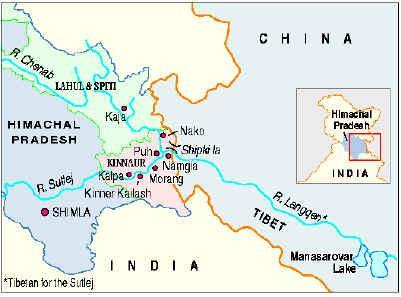
Figure 2.
General location of
The Shipki
La was a major trade route between
The research team consisted
of three senior scientists from the
Reconnaissance level survey
was conducted along the terrace systems on the south side of the
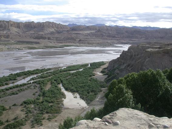
Figure 3. View of
terrace systems on south side of
Survey, then, was focused on
the upper terraces, especially 4-6, although terrace 1 was examined as a rough
check on the proposed dating scheme.
Because this was a
reconnaissance level survey, strict maintenance of survey transects was not a
priority. Instead, terrace margins were
walked in a roughly parallel manner, and site and component locations were
mapped with Trimble Geo XH high-resolution global
positioning system (GPS) devices.
More than 150 archaeological
sites of all time periods were discovered during the survey,
and of these, 31 are likely to date to pre-Holocene, possibly Paleolithic
cultural periods. Tool forms and
reduction sequences in this region are poorly-defined, and since there are no
excavated sites on the central Plateau with secure chronometric dating, only
cross-dating of tool forms can be used to assess preliminary estimates of age.
Two distinct reduction
strategies are observed: 1) a large flake/blade process, in which globular or
irregularly-shaped nodules of local raw materials are struck to produce large
flakes and/or large blade-like flakes (Fig. 4) and 2) a “splinter” technology,
in which roughly rectangular nodules of local raw material are struck to create
blade-like splinters of distinctive shape (Fig. 5).
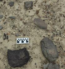
Figure 4.
Large flake reduction
debris in situ.
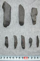
Figure 5.
“Splinter” reduction debris.
Objects similar to the large
flakes and flake/blades are relatively common further east on the Plateau
(Aldenderfer and Zhang 2004), but similar reduction debris can also be found
further to the west along the Sutlej drainage in
One clearly diagnostic artifact
discovered during survey was a Levallois-like flake found on Terrace 7 (the
oldest terrace), see Fig. 6.
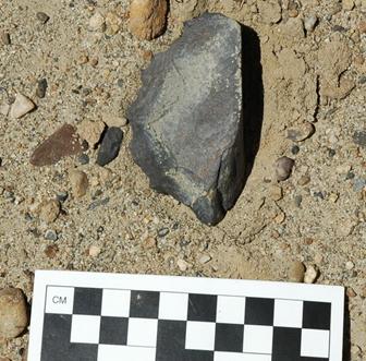
Figure 6.
Levallois-like
flake found in situ.
This technology is
well-represented in
Of the 31 sites and
components found in this portion of the study area, 18 are included in the
flake/blade reduction category, and 13 exhibit
predominantly splinter technology.
Survey was also conducted in
the upper Sutlej drainage near the modern
In this area, a total of 18
sites and components possibly dating to the Paleolithic were discovered. Of
these, one contained a Levallois-like core or flake. Eleven of the components (including that with
the Levallois-like flake) were characterized by the flake/blade reduction
strategy, and nine reflected the splinter technology.
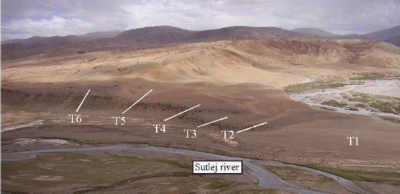
Figure 7.
Terrace sequence on the upper
Conclusions
This aspect of our research
has demonstrated that there was substantial aceramic (presumably preceramic) lithic utilization of the terraces of the
Future expeditions will
conduct further surveys as well as seek out sites in the drainage that have
stratigraphic integrity and the potential of chronometric dating so as to
address the question of this potential early migration in a systematic and
conclusive manner.
Paleolithic investigations conducted in northern
Introduction
Our work in the Amdo region (安多地区) of the northern Qinghai-Tibet
Plateau (清-藏高原) focused on survey for and test excavation of
archaeological sites in central and southern
A team of eight researchers
conducted fieldwork during the months of June and July, 2007. The team
included three senior scientists from the
As a follow-up to work
conducted in 2006, we revisited five geological localities at Qinghai Hu (青海湖,
In 2007 we returned to an
archaeological site (first identified in 2006) exposed in a gravel pit
associated with the Hudong Yangchang
Dam. The site consisted of a circular hearth or fire-pit with an
associated scatter of stone tools. The feature was 14C dated
to ~13,000 calendar years before present and our 2007 visit was focused on
increasing the size of the stone tool sample. The Dam Site is the third
locality in the
We identified a new
archaeological site at the canyon mouth near the settlement of “151” (一五一). This is a large, heavily
organic midden containing abundant bone, some coarse ceramics, and
microblades. In appearance and material content, the “151” site is
similar to Jiangxigou 2 (江西沟 2; located ~15 km to the east),
which is dated to between 6-9,000 calendar years ago. Future work in the
area may involve excavations at “151.”
Archaeological Reconnaissance in the
The Gonghe
Basin (共和盆地) lies south of the Qinghai Nanshan
(青海南山) Mountains and represents one possible route that humans
may have traversed onto the Tibetan Plateau. There is a reasonably
well-known mid-Holocene Neolithic complex, the so-called Zongri
Culture (总日文化), already identified in the
We also surveyed for
prehistoric sites in the region surrounding the Lin Xia
(林峡Lin Gorge).
The geological setting in this area, however, is poor for archaeological site
preservation and results were not encouraging.
Investigations in the Xiadawu & Donggi Cona Regions
Our work in higher elevation
areas (above 4000 m asl)
concentrated on terraces of the
Donggi Cona is a large tectonic freshwater
lake at an elevation of approximately 4100 m asl that drains to the north (toward Xiangride 香日德). At least one +10-meter beach documents
higher lake stands in the basin at some presently unknown earlier time.
Our 2007 survey of this lake basin identified two surface localities on the
+10-meter strandline containing bladelet and microblade technologies similar to
those from Xiadawu.
As it appears that Donggi Cona
is periodically dammed by floodwater events where it discharges, it is possible
that individual shorelines may have been occupied several times over long
periods. We found multiple
archaeological sites on various shorelines and initially thought they might be
of assistance in dating lake level fluctuation.
However, if the lake’s level is not climate controlled, the presence of
these cultural remains may not be of great utility in understanding its complex
history. Future work on the Donggi Cona shorelines will
include the collection of multiple ostracod and/or
pollen samples from laminated deeper water sediments and/or Optically
Stimulated Luminescence (OSL) samples from the sandy
shoreline to help resolve these difficult chronometric problems (e.g., Wang et
al. 2004).
Excavations in Tu
Jiu Rockshelter
Originally tested in 2005,
our team returned to Tu Jiu
Rockshelter (秃鹫小洞), west of Dulan
(杜兰县), in 2007 and extended our trial excavation down to a
depth of 3.3 meters below the present ground surface. We identified a hearth below one previously
dated at roughly 3,900 radiocarbon years ago and encountered a layer of sheep
dung underlying this feature. Should
these fecal pellet samples yield dates of 4-5,000 calendar years old or older,
we will attempt to extract DNA and define what may be some of the earliest
evidence for sheep domestication in
References Cited
Aldenderfer, M.
2006 Modeling plateau
peoples: the early human use of the world's high plateaux.
World Archaeology.38(3): 357-370.
Aldenderfer,
M. and Y. Zhang
2004
The prehistory of the Tibetan Plateau to the 7th C. AD: Perspectives
and research from
Corvinus, C.
2002 Arjun 3--a Middle Paleolithic site in the Deokuri Valley, Nepal. Man and Environment 27:
31-44.
Hedin, S.
1909 (1999) Trans
Hou, G., and Liu, F.
2004 Pre-history and climate
change of eastern
James, H. and M. Petraglia
2006
Modern human origins and the evolution of behavior in the later Pleistocene
record of
Liu, F., Hou,
G., Zhang, Y., Zhang, Z., Xu, C., Zhou, Q., and
Zhang, H.
2005 The impact of abrupt
climate change in mid-Holocene on the prehistoric culture in northeast
Wang, J., and Xiong, W.
2004 Relationship between the
ancients’ migration and climate change in the later period of late Pleistocene
in
Xie, D.
2002 甘肃青海省史前考古学
Yuan, B., Huang, W., and D. Zhang
2007 New
evidence for human occupation of the northern